


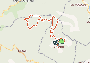
Monts de la Fage

ARVIEU
User

Length
11.7 km

Max alt
914 m

Uphill gradient
450 m
Km-Effort
17.7 km

Min alt
575 m

Downhill gradient
449 m
Boucle
Yes
Creation date :
2014-12-10 00:00:00.0
Updated on :
2014-12-10 00:00:00.0
3h49
Difficulty : Medium

FREE GPS app for hiking
 SityTrail
IGN / Geographical institutes
SityTrail Plus
The world is yours!
About
Trail Walking of 11.7 km to be discovered at Occitania, Gard, La Cadière-et-Cambo. This trail is proposed by ARVIEU.
Description
Cambo-Les Monts de la Fage
Positioning
Country:
France
Region :
Occitania
Department/Province :
Gard
Municipality :
La Cadière-et-Cambo
Location:
Unknown
Start:(Dec)
Start:(UTM)
564374 ; 4869831 (31T) N.
Comments